Cross layer filtering
The “querylayer” module adds a few extra filter functions that allow for cross layer filtering, that is, the ability to find in layer A features that have a certain relationship with features in layer B. This can be used, for example, to find all bus stops within a certain distance from a shop, or all coffe shops in a certain city district. Since filter functions are widely supported in GeoServer this cross layer filtering can be applied in SLDs, CQL filters and WFS requests alike.
Installing the ‘querylayer’ module
Download the ‘querylayer’ extension corresponding to your version of GeoServer.
Warning
Make sure to match the version of the extension to the version of the GeoServer instance!
Extract the contents of the archive into the WEB-INF/lib directory of the GeoServer installation.
To check the module is properly installed get the WFS 1.1 capabilities from the GS home page, the Filter_Capabilities section should contain a reference to a new function named ‘queryCollection’
1 2 3 4 5 6 7 8 9 10 11 12 13 14 15 16 17 18 | ...
<ogc:Filter_Capabilities>
...
<ogc:ArithmeticOperators>
...
<ogc:Functions>
<ogc:FunctionNames>
...
<ogc:FunctionName nArgs="-1">queryCollection</ogc:FunctionName>
<ogc:FunctionName nArgs="-1">querySingle</ogc:FunctionName>
...
</ogc:FunctionNames>
</ogc:Functions>
</ogc:ArithmeticOperators>
</ogc:Scalar_Capabilities>
...
</ogc:Filter_Capabilities>
...
|
Function reference
| Name | Arguments | Description |
| querySingle | layer: String, attribute:String, filter:String | Queries the specified layer``applying the specified (E)CQL ``filter and returns the value of attribute from the first feature in the result set. The layer name should be qualified (e.g. topp:states), the filter can be INCLUDE if no filtering is desired |
| queryCollection | layer: String, attribute:String, filter:String | Queries the specified layer``applying the specified (E)CQL ``filter and returns the list of the values from attribute out of every single feature in the result set. The layer name should be qualified (e.g. topp:states), the filter can be INCLUDE if no filtering is desired. Will throw an exception if too many results are being collected (see the memory limits section for details) |
| collectGeometries | geometries: a list of Geometry objects | Turns the list of geometries into a single Geometry object, suitable for being used as the reference geometry in spatial filters. Will throw an exception if too many coordinates are being collected (the results of queryCollection cannot be used as is) |
Optimizing the module speed
In order to have the module run at full speed on the 2.1.x series it is necessary to add the following parameter as a system variable when starting the Java Virtual Machine:
-Dorg.geotools.filter.function.simplify=true
This will make sure the functions are evaluated just once per query instead of once per feature matched by the filter. The flag is not necessary on trunk (2.2.x series) and hopefully this behavior will become the default on 2.1.x as well.
Memory limits
The query and geometry collection functions are not really performing a database style join, instead they do execute a query against the layer every time they are executed and load the result fully in memory. Both queryCollection and collectGeometries are thus at risk of filling up the server memory with data if the layer being queries is large, or if the geometries being collected are few but very large. Since this might threaten the server stability there are built in limits to what can be collected:
- at most 1000 features will be collected by queryCollection
- at most 37000 coordinates (1MB worth of Coordinate objects) will be collected by collectGeometries
Both limits can be overridden by setting appropriate values either as system variable, servlet context variables, or enviroment variables:
- set QUERY_LAYER_MAX_FEATURES to alter the max number of features collected by queryCollection
- set GEOMETRY_COLLECT_MAX_COORDINATES to alter the max number of coordinates collected by collectGeometries
WMS Examples
The following examples use the sf:bugsites, sf:roads and sf:restricted demo layers available in the standard GeoServer download.
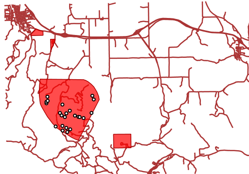
Get only the bugsites overlapping the restricted area whose category is ``3``. The CQL filter on bugsites is INTERSECTS(the_geom, querySingle('restricted', 'the_geom','cat = 3')), the full request is:
http://localhost:8080/geoserver/wms?LAYERS=sf%3Aroads%2Csf%3Arestricted%2Csf%3Abugsites&STYLES=&FORMAT=image%2Fpng&SERVICE=WMS&VERSION=1.1.1&REQUEST=GetMap&EXCEPTIONS=application%2Fvnd.ogc.se_inimage&SRS=EPSG%3A26713&CQL_FILTER=INCLUDE%3BINCLUDE%3BINTERSECTS(the_geom%2C%20querySingle(%27restricted%27%2C%20%27the_geom%27%2C%27cat%20%3D%203%27))&BBOX=589081.6705629,4914128.1213261,609174.02430924,4928177.0717971&WIDTH=512&HEIGHT=358
and the result looks like:
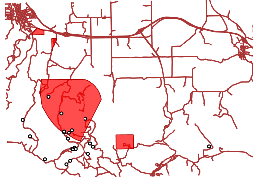
Get all bugsides within 200 meters from roads. The CQL filter looks like DWITHIN(the_geom, collectGeometries(queryCollection('sf:roads','the_geom','INCLUDE')), 200, meters), the full request is:
and the result looks liie:
WFS Examples
The following examples use the sf:bugsites, sf:roads and sf:restricted demo layers available in the standard GeoServer download.
Get only the bugsites overlapping the restricted area whose category is ``3``:
1 2 3 4 5 6 7 8 9 10 11 12 13 14 15 16 17 | <wfs:GetFeature xmlns:wfs="http://www.opengis.net/wfs"
xmlns:sf="http://www.openplans.org/spearfish"
xmlns:ogc="http://www.opengis.net/ogc"
service="WFS" version="1.0.0">
<wfs:Query typeName="sf:bugsites">
<ogc:Filter>
<ogc:Intersects>
<ogc:PropertyName>the_geom</ogc:PropertyName>
<ogc:Function name="querySingle">
<ogc:Literal>sf:restricted</ogc:Literal>
<ogc:Literal>the_geom</ogc:Literal>
<ogc:Literal>cat = 3</ogc:Literal>
</ogc:Function>
</ogc:Intersects>
</ogc:Filter>
</wfs:Query>
</wfs:GetFeature>
|
Get all bugsides within 200 meters from roads:
1 2 3 4 5 6 7 8 9 10 11 12 13 14 15 16 17 18 19 20 | <wfs:GetFeature xmlns:wfs="http://www.opengis.net/wfs"
xmlns:sf="http://www.openplans.org/spearfish"
xmlns:ogc="http://www.opengis.net/ogc"
service="WFS" version="1.0.0">
<wfs:Query typeName="sf:bugsites">
<ogc:Filter>
<ogc:DWithin>
<ogc:PropertyName>the_geom</ogc:PropertyName>
<ogc:Function name="collectGeometries">
<ogc:Function name="queryCollection">
<ogc:Literal>sf:roads</ogc:Literal>
<ogc:Literal>the_geom</ogc:Literal>
<ogc:Literal>INCLUDE</ogc:Literal>
</ogc:Function>
</ogc:Function>
<ogc:Distance units="meter">100</ogc:Distance>
</ogc:DWithin>
</ogc:Filter>
</wfs:Query>
</wfs:GetFeature>
|